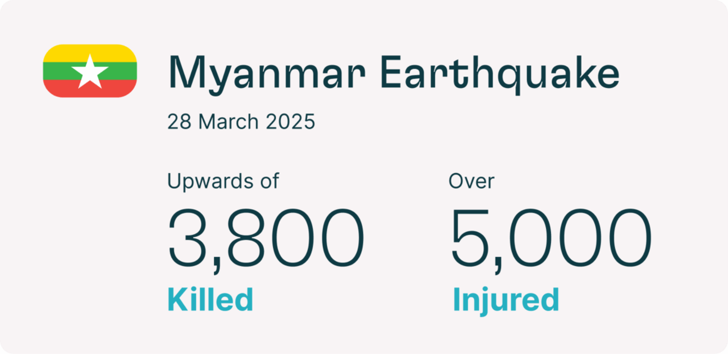
A 7.7-magnitude earthquake struck 16 km (10 miles) north-northwest of Sagaing, Myanmar, at a shallow depth of 10 km (6.2 miles) around 12:50 local time on 28 March. A 6.4-magnitude aftershock followed shortly after. The earthquake caused severe damage to buildings and infrastructure, especially in Mandalay, Sagaing and Nay Pyi Taw. More than 3,800 people were killed and over 5,000 injured. Authorities declared a state of emergency in Sagaing, Magway, Mandalay and Bago regions, Nay Pyi Taw and northeastern Shan State.
The quake also damaged roads and rail lines, including the Ava and Irrawaddy Bridges over the Irrawaddy River between Mandalay and Sagaing. Telecommunications and utility services were heavily disrupted. Authorities warned of landslides from aftershocks and wildfire risks during the dry season. Mandalay, Sagaing and Nay Pyi Taw were the worst-hit areas.
What to Expect:
Travellers should expect disruptions to travel and essential services in affected areas. Authorities were on high alert for landslides caused by aftershocks and the risk of wildfires amid the height of the dry season. Severe disruptions to essential goods and services, including electricity, water supplies, telephone and internet services, persisted in and around the Sagaing and Mandalay regions. Over 6,730 telecommunications stations were reportedly damaged across the country.